How to create a Google Earth file of elevation contours?
To create a Google Earth file (KMZ) of elevation contours, follow these steps:
- 1. Go to contourmap.app
- 2. Select the area you want to contour
- 3. Generate a preview
- 4. Click on the 'Export' button
- 5. Select 'Google Earth File (.kmz)' from the dropdown menu
- 6. Download your KMZ file
How to create an image map of elevation contours?
To export an image map of elevation contours, follow these steps:
- 1. Go to contourmap.app
- 2. Select the area you want to contour
- 3. Generate a preview
- 4. Click on the 'Export' button
- 5. Select 'Image' from the dropdown menu
- 6. Download your high-resolution image file
How to create DXF of elevation contours?
To create a DXF of elevation contours, follow these steps:
- 1. Go to contourmap.app
- 2. Select the area you want to contour
- 3. Generate a preview
- 4. Click on the 'Export' button
- 5. Select 'DXF' from the dropdown menu
- 6. Download your DXF file
How to create GeoJSON of elevation contours?
To create a GeoJSON of elevation contours, follow these steps:
- 1. Go to contourmap.app
- 2. Select the area you want to contour
- 3. Generate a preview
- 4. Click on the 'Export' button
- 5. Select 'GeoJSON' from the dropdown menu
- 6. Download your GeoJSON file
How to create a Shapefile of elevation contours?
To create a Shapefile of elevation contours, follow these steps:
- 1. Go to contourmap.app
- 2. Select the area you want to contour
- 3. Generate a preview
- 4. Click on the 'Export' button
- 5. Select 'Shapefile' from the dropdown menu
- 6. Download your Shapefile (.shp) and associated files
How to create SVG of elevation contours?
To create an SVG of elevation contours, follow these steps:
- 1. Go to contourmap.app
- 2. Select the area you want to contour
- 3. Generate a preview
- 4. Click on the 'Export' button
- 5. Select 'SVG' from the dropdown menu
- 6. Download your SVG file
How do I overlay contours on Google Earth?
To overlay contours on Google Earth, follow these steps:
What is the difference between contours with LiDAR and standard data?
Contours are made from an elevation data source and their accuracy depends on it.
- Standard - Standard data is derived from various sources and is good enough for many uses where LiDAR data is not available.
- High (LiDAR) - LiDAR data is a highly accurate laser mapping method which provides a higher level of detail but is harder to obtain and is not available everywhere.
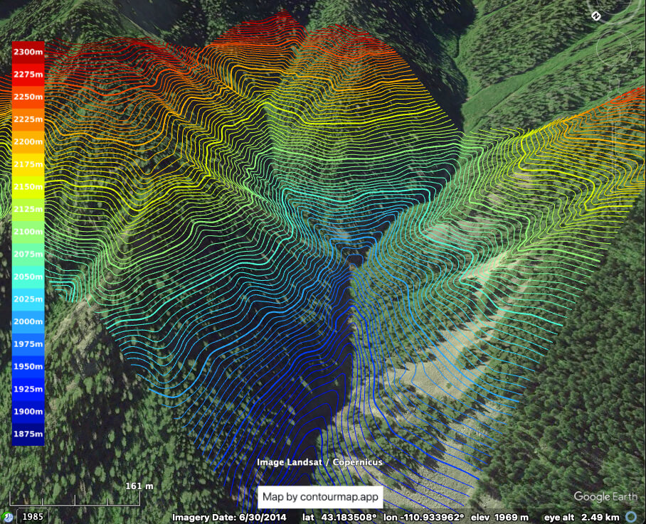
How do I overlay elevation contours on satellite imagery?
First, create your elevation contour map by selecting the area you want to contour and generating a preview on contourmap.app. Next, you have two options to overlay the contours on satellite imagery:
What is the OpenStreetMap roads and structures data, and how accurate is it?
The OpenStreetMap (OSM) roads and structures data used in our web app is a collection of geographic information contributed by a global community of volunteers. It includes roads, buildings, and other features and makes for an amazing and invaluable resource.
- Accuracy - The information in OSM is added by volunteers, meaning its accuracy and completeness can vary depending on the region. Some areas are highly detailed and frequently updated, while others might lack coverage or have outdated data.
- Tags - Each feature in OSM, such as roads and buildings, is described using tags, which provide additional information about the type and characteristics of each element. For more details on the different types of tags used, see the OSM Map Features documentation.
- Potential Misalignment - The OSM roads and structures may sometimes appear slightly shifted when compared to satellite imagery. This happens because of differences in how datasets are georeferenced, leading to small discrepancies, especially in regions with inconsistent or outdated mapping sources.
What data sources does ContourMap.app use, and what are the licensing requirements?
ContourMap.app generates maps using elevation, terrain, and geographic data from multiple third-party sources, including open-data and commercially licensed providers. Licensing requirements vary by source and by how you intend to use your maps and exports.